


No-code hotspot editor
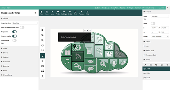
Draw polygon, rectangle, ellipse, icon and connected-shape hotspots with drag and drop.
Image Maps for SharePoint is a no-code web part that turns any image into interactive navigation. Draw hotspots over a floor plan, org chart, process diagram, campus map or product photo, choose what each one opens, and publish it on any SharePoint page or Teams tab.
Replace rows of buttons and link lists with one clear picture people actually click. Hotspots can follow links, open SharePoint content in a popup or side panel, jump between floors, or show tooltips pulled from a SharePoint list.
An image map is one image with several clickable areas, called hotspots. Each hotspot can open a different page, document, popup or side panel. Modern SharePoint cannot do this out of the box: the Image web part links the whole picture to a single address, and modern pages block the HTML <map> tag and custom script. Image Maps for SharePoint adds the missing feature as a SharePoint Framework (SPFx) web part that runs inside your own Microsoft 365 tenant. Compare every method in our step-by-step guide.
Click a room, desk area or facility to open its page, booking link or details. Multiple floors in one map.
Replace link lists with one branded image that routes people to departments, services and key documents.
Make each team or person on a chart clickable, with tooltips that can be kept up to date from a SharePoint list.
Link every stage of a process diagram to the policy, form or guidance people need at that step.
Start from 50 built-in SVG maps of countries, continents and the world to show offices, regions and contacts.
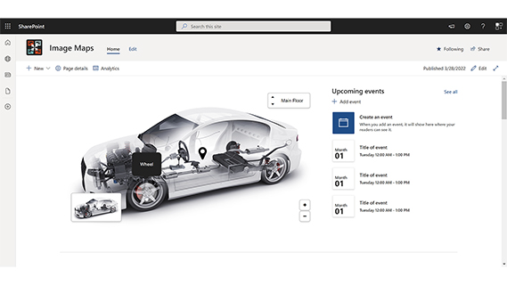
Label parts of a machine, vehicle or product photo with popups, specs, manuals and training videos.
Built for SharePoint Online and Microsoft 365 as a SharePoint Framework (SPFx) web part. Show the same map as a web part, a full page or a Microsoft Teams tab. See every feature and pricing.

Draw polygon, rectangle, ellipse, icon and connected-shape hotspots with drag and drop.
Open SharePoint or Microsoft 365 content in a popup or side panel, follow a link, or run a script.
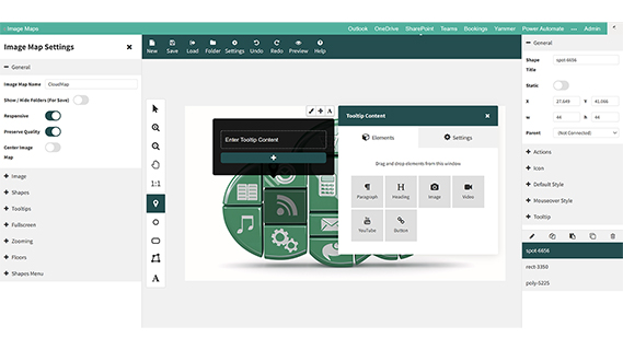
Pull tooltip text from a SharePoint list so maps stay current without re-editing.
Stack floors or views in one map, with go-to-floor hotspots and an optional auto-sliding carousel.
Show a map only to selected SharePoint users or groups, using your existing permissions.
Works on desktop, tablet and phone, with zoom, touch and keyboard support. UK-based support included.
Every licence starts with a free 14-day trial with full functionality. Licences are based on the number of users in your Microsoft 365 tenant: Site £999/year (up to 500 users), Site Collection £2,999/year (up to 2,500 users) and Tenant £4,999/year (up to 10,000 users). Prices exclude applicable taxes.
Yes, but not with the built-in web parts. The standard Image web part links the whole picture to one address. Image Maps for SharePoint adds a no-code web part where you draw several hotspots on one image, and each hotspot can open a page, document, popup, side panel or another floor.
Modern SharePoint pages do not let you paste raw HTML or script, so the classic <map> and <area> technique is stripped out. The old workaround of uploading an ASPX file and showing it in the Embed web part needs custom script, and since November 2024 SharePoint Online switches custom script off again every 24 hours. A web part built on the SharePoint Framework (SPFx) avoids both problems.
Yes. The same image map can be shown as a web part on a SharePoint page, as a full-page app, or as a Microsoft Teams tab.
Yes. Upload the floor plan, draw a hotspot over each room, desk area or facility, and link it to the right page, document or popup. Multi-storey buildings can use multiple floors in one map, with a go-to-floor action and an optional auto-sliding carousel. See our floor plan guide.
No. Hotspots are drawn with a drag-and-drop editor, and actions, styles and tooltips are set from menus. Anyone who can edit a SharePoint page can build an image map.
Image Maps is installed from Microsoft AppSource into your own Microsoft 365 tenant. Your image maps are saved in SharePoint in your tenant and it works with your existing SharePoint permissions, so no data leaves your Microsoft 365 environment.
Yes. You get a 14-day free trial with full functionality from Microsoft AppSource. After the trial you buy a licence directly from APPS 365 or request an invoice for purchase order processing.
Licences are annual and based on the number of users in your Microsoft 365 tenant: Site £999 a year (up to 500 users), Site Collection £2,999 a year (up to 2,500 users) and Tenant £4,999 a year (up to 10,000 users). Prices exclude applicable taxes. Contact us for tenants above 10,000 users.
Microsoft retired SharePoint Add-ins in SharePoint Online in April 2026. Image Maps had already moved to the SharePoint Framework: the old SharePoint-hosted add-in and the SPFx web part are now one Image Map web part that you edit and display in place on the page. If you still use the old add-in, contact us for help moving to the web part.